Skip to content
Jordan reconstruction 3

Raising the Jordan

Thirty years ago, I wrote a booklet titled “Jordan Creek: Story of an Urban Stream.” The book chronicled the adventures and misadventures of the stream, from the founding of a village on its banks to its burial under tons of concrete. Despite its concrete straightjacket and ever-present trash, I suggested, the creek retained certain values—some of the same values that attracted the city’s founder, John Polk Campbell—clear water, aquatic life, pleasing scenery.

That booklet was written during the early planning phase of Jordan Valley Park. I asked readers to “imagine how the Jordan Valley Park movement, through a concerted community effort to embrace and renew those kinds of values, could someday provide an avenue for the Jordan to be reborn.” I’m happy to report that the re-birthing process is now fully underway.

The story of Jordan Creek parallels those of many streams that over the years found themselves surrounded by a city. These are largely sad stories of degradation, destruction, denial, and apathy. For many of these streams, however, modern stories include lofty visions of rehabilitation and rejuvenation. Jordan Creek is one of these.

This Jordan Creek story begins in the 1830s, at the time of the city’s founding. John Polk Campbell built his cabin on a low limestone bluff overlooking the creek. Nearby was a linear crack in the top of the bluff, what we would today call a “karst window,” a vertical cave or fissure opening downward into a subterranean pool—a “natural well of wonderful depth,” Polk’s granddaughter would later write. It isn’t hard to imagine Campbell chucking a big rock into the hole and smiling when he heard a deep “ker-plunk,” the comforting sound of a “bottomless” water supply.

In those early days, the Jordan was a cool, sparking clear, spring-fed stream. Its deeper pools held sunfish and bass; riffles swarmed with flashing minnows. An early mayor of Springfield remembered as a kid catching catfish in the creek and putting them in a tank at the Eagle Mill. As late as the 1950s, many Springfieldians recalled spending their evenings under the shade trees that once lined the Jordan’s banks, watching people fish or play in the water.

By the late 1880s, however, Jordan Creek had largely become an unsightly mess and a major nuisance, especially downstream of the city where it “reeked with poisons” from the gas plant. It had also become a destroyer, rising out of its banks after heavy rains, flooding the homes and businesses lining its banks, causing millions of dollars in property damage. There were calls to wall the stream into a flume or built tunnels to convey the floodwaters safely out of town. A newspaper in 1927 suggested that “ultimately the entire creek will be covered from the east to the west city limits.”

At the time, walling and confining the stream seemed like a good solution to a vexing urban problem. Flumes or tunnels would convey raging floodwaters safely out of the city. With Works Progress Administration (WPA) funds in the 1930s, this dream became a reality, at least for downtown segments of the Jordan, which were encased in concrete tunnels. With these additions, the old creek was allowed to die in peace—out of sight, out of mind—buried in a concrete tomb.

In the 1930s, some citizens expressed disgust that the founding waters had been so mistreated. Newspapermen describing the stream’s plight wrote that Jordan Creek had reached “the twilight of its existence.” There were a few efforts at restoration in that decade, however, mostly cosmetic work by the “City Beautiful” movement to plant flowers and clean up dumps in vacant lots, like “rubbish and oil wastes” at the former Kelly Coal Company.

In 1933, an architect submitted plans for “Jordan Valley Park” to be located between Jefferson and Robberson Streets. A walled “Jordan Creek Canal” ran thought the middle of the park, spanned by a stone footbridge. The plan would have meandering paths, a Japanese garden with a curving wooden bridge, and a “grotto” complete with a waterfall—a project eerily foreshadowing the Jordan Valley Park development of today. But it was not to be.

Today, major restoration work is finally underway. Downtown sections of Jordan Creek, once buried and conveyed in tunnels, are being “daylighted.” One section of the creek east of National has already been opened to the sun. With better stormwater management, runoff into the creek continually improves in quality. A person might ask the question: “If water quality in the creek is better, is daylighting even necessary?

The answer, of course, is yes. The sun drives aquatic ecosystems, just like it does on the land. Photosynthetic plants like grass, trees and algae are the basis of all terrestrial and aquatic food webs. So, if we want a stream and the life it contains to be healthy, they must have sunlight. Further, solid concrete offers nothing in the way of habitat for aquatic creatures.

But there is another reason for daylighting. When we began thinking of urban streams simply as conveyances for waterborne wastes and dirty water, we demeaned them, relegating them to a low status. We validated this view by calling them “drainage ditches,” or even “storm sewers.” In our minds, they became ugly blights; something to bury, or ignore.

When people no longer cared about the stream, they felt no guilt in trashing it. When others saw trash in the stream, and no one bothered to remove it, it reinforced, to them, the stream’s worthlessness. It began a tragic downward spiral. The more the stream degraded, the less we cared about it.
When we daylight Jordan Creek, we invite the public back in to experience, up close and personal, the founding waters. When people perceive that the stream’s water quality is good, they’ll let their kids wade in it, or catch crawdads. As more people come to realize that this is, in fact, a real stream—not a drainage ditch or storm sewer—then they’ll care more about it. They’ll get angry when they see someone trashing it. And the more people that care about the stream, the larger the constituency advocating protection and further rehabilitation. The stream begins an inspiring upward spiral—the more people that care, the better the creek will become.

It's hard to imagine the sparkling clear, life-filled waters that John Polk Campbell saw when he first built his cabin. There is virtually no chance that a creek exactly like that will ever again exist in downtown Springfield. But given where we are in the story, that doesn’t have to be the goal. What is important is that we transform the Jordan back into a living stream—no longer a tunnel, a drainage ditch, or a storm sewer.

When we can find a variety of life forms swimming or wading in the creek, or patrolling its banks, or roosting in its streamside trees; when the people of Springfield have become proud that their founding waters have been rehabilitated, rejuvenated, and restored; then we can truly say that Jordan Creek has been raised from the dead.
Screenshot 2025 07 13 090425

The Drownings on Bull Creek


Three boaters have drowned on Bull Creek since 2019, all at or near the same spot. In 2017, a riverside landowner built a concrete low-water bridge across the stream to connect his properties on either side. At low water, boaters were forced to stop at the bridge and drag their boats over it. Pipe culverts had been built into the bridge to allow water to flow under it, but these openings quickly became plugged with gravel and brush, forcing water to flow over the top.

At low water, it wasn’t a big deal—one simply slid his or her boat over the smooth, algae-lubricated surface of the bridge. But at high water, it became a very big deal. The bridge acted like a low-head dam, creating a dangerous hydraulic that could flip boats and drown boaters.


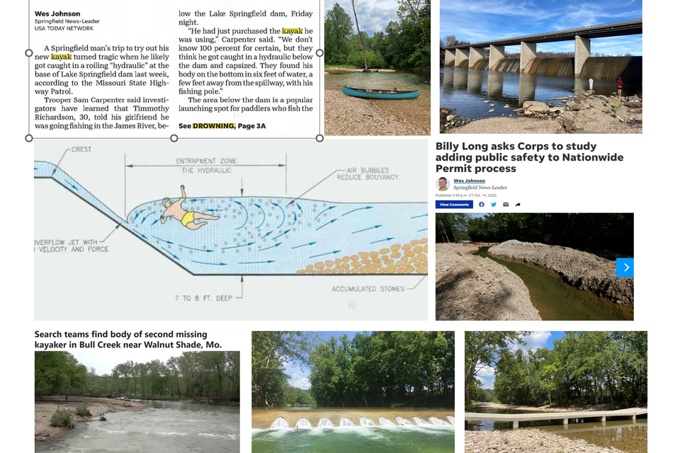
Water flowing over the top of a dam (or bridge) forms what is known in river runners’ parlance as a “hydraulic,” or “hole.” The flowing mass of water coursing over the crest of the dam or bridge plunges to the bottom on the downstream side, pushing the water below the drop downward. Water near the surface, just below the drop, actually flows upstream to fill in the valley, the “hole,” created by the downwardly plunging flow (see diagram).

The result is that objects that float, like a log, or a barrel, or a person in a life jacket, can become trapped in the hole’s mean embrace. Holes produced naturally, as by boulders, are usually irregular in shape, often providing for escape at the ragged edge. But if it’s a smooth hydraulic, like one formed by a dam or bridge, a person can get hopelessly trapped, unable to swim out. 


For boaters who aren’t prepared for what the water will do to them, the violence of a large hydraulic will almost invariably flip the boat. With luck, the person, now in the water, will flush out downstream. If wearing a life jacket they can swim to shore or if someone is nearby, be rescued.

But in higher water, and particularly with no life jacket, a swimmer may be pounded by rocks and waves and have a long swim or struggle to get to shore. A long, panicky swim in cold water and powerful currents, trying to keep one’s head above water, quickly saps the energy. Hypothermia, at least, and often drowning can be the result.


The three Bull Creek boaters drowned between 2019 and 2020, after the installation of the bridge, and all at high or medium-high water levels. At least two people, one of whom drowned, were not aware that the bridge had been installed since they last floated Bull Creek.

After the drowning in June 2020, the Army Corps of Engineers inspected the bridge and determined that it had not been properly constructed. The Corps directed the owner to tear out the structure and replace it with a new one in compliance with permit requirements. The owner did just that.


But during the re-construction process, the contractors excavated a 900-foot long trench in the gravel streambed below the construction site, apparently to “dewater” it so they could pour concrete. When I saw this huge trench in the riverbed (see photo), I went ballistic. I called the Department of Natural Resources and Missouri Department of Conservation to complain about the terrible environmental damage.

The drownings on Bull Creek made me aware of serious shortcomings in rules to prevent these kinds of tragedies. I learned that:

1. The Corps has a “goal” of inspecting at least 20% of small river crossings, which they consider “de minimus” structures. In other words, the Corps, which focuses mainly on “big” projects like dams and river navigation, considers this little bridge over Bull Creek hardly worthy of its attention.

2.
The Corps never inspected the bridge to make sure it was constructed according to the permit. (As indicated above, they don’t have to). Not long after the bridge was installed, a flood washed out the approaches on both ends.

3. 
The contractor then repaired the bridge, raising it higher than it had been before. At that point, the bridge no longer conformed to the original design that was permitted.

4. Upon being made aware of the bridge's dangerous nature, the Corps told the owner the bridge would have to be removed and a new, safer, raised-span bridge installed. If the bridge had never been linked to the drownings, by me and the media, it might have never been removed.

5. It was very difficult to find information about how, or even exactly where, the drownings occurred. Non-emergency personnel are restricted in obtaining accident reports that might shed light on what exactly caused the drownings.

6. The new raised span bridge is safer and allows for fish migration, but it is so low to the water that a canoe can’t pass under it at most levels. This, plus the closing of accesses, has greatly constrained the floating opportunities on Bull Creek.

The button shows how dangerous hydraulics form below dams, particularly at high water. In the case of the Lake Springfield dam, the “boils” (where water that has plunged to the bottom rises again) are up to twenty feet from the foot of the dam. All the surface water and floating logs within this distance are moving back TOWARD the dam. This shows that a swimmer would also be pulled back into the hydraulic. This is a KILLING MACHINE. At the Ozark Dam, the hydraulic can be seen holding and recirculating logs and floating objects.
Killer Hydraulics
James river collage

James River Flood, 2017

The left photo of Y-Bridge at Galena, medium water level. Upper right is Y-Bridge during the flood of 2017. The button below shows a view of the flooding from the deck of the Y-Bridge shot near the peak of the 2017 flood, which hit a peak of 84,100 cubic feet per second on April 30. This was the second highest flood since the gage was installed at Galena in 1921. The men working for the USGS are taking a flow measurement.

The "raft" on a rope is an acoustic doppler current profiler (ADCP). It shoots sound waves down into the river. The waves bounce off of particles flowing by. The speed of the particles (and thus the current velocity) is measured using the doppler effect. It's the same principle as why a train whistle lowers in pitch after the train passes by you--the sound waves are being stretched out. The faster the particles in the river are going, the steeper the drop in pitch.

The ADCP measures the speed of particles from the top to the bottom of the river. Current velocity is highest near the top of the water surface, and toward the middle of the river. This is because the banks, river bottom, and even the air above the river exert friction that slows the current.

Because of these variations, a flow (discharge) measurement is made by dividing the river channel into segments. The depth of the channel is known for each segment. Depth times width of the segment equals square feet of area in the segment. Multiply square feet of a segment times average velocity (feet per second) from the ADCP gives cubic feet per second for that segment. Add all the segments together to get total discharge in cubic feet per second. This is how discharge is usually reported by the USGS.

When I think about a discharge of 80,000 cubic feet per second, I try to visualize a wall of water one foot thick and 80,000 square feet in size (maybe 800 feet wide by 100 feet deep) going by every second. So the highest discharge of the Mississippi River ever recorded at St. Louis (1993), a little over one million cubic feet per second, can be thought of as a wall of water 10,000 feet wide (2 miles) and 100 feet deep flowing by every second!

  
Flood at Y-Bridge